Please use this identifier to cite or link to this item:
http://hdl.handle.net/10267/14842| Title: | BIOL INTD 225, Geographic Information Systems, Spring 2012 |
| Authors: | Boyle, Sarah A. |
| Keywords: | Biology, Department of;Syllabus;Text;Academic departments;Curriculum;2012 Spring |
| Issue Date: | Jan-2012 |
| Publisher: | Memphis, Tenn. : Rhodes College |
| Series/Report no.: | Syllabi CRN; |
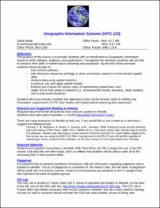
| Abstract: | The purpose of this course is to provide students with an introduction to Geographic Information Systems (GIS) software, analyses, and applications. Throughout the semester students will use GIS to enhance their skills in mathematical reasoning and expression. By the end of the semester students should be able to: - Use ArcGIS software; - Use deductive reasoning and logic to draw conclusions based on numerical and spatial data; - Analyze data using spatial statistics; - Construct, run, and apply spatial models; - Explore and critique the various ways of representing spatial data; and - Apply GIS to their areas of interest (e.g., environmental issues, business, urban studies) and to real-world situations. |
| Description: | This syllabus was submitted to the Office of Academic Affairs by the course instructor |
| URI: | http://hdl.handle.net/10267/14842 |
| Appears in Collections: | Course Syllabi |
Files in This Item:
| File | Description | Size | Format | |
|---|---|---|---|---|
| 2012_spring_INTD 225-GIS-S12Boyle.pdf | 152.32 kB | Adobe PDF |  View/Open |
Items in DSpace are protected by copyright, with all rights reserved, unless otherwise indicated.