Please use this identifier to cite or link to this item:
http://hdl.handle.net/10267/16135
Full metadata record
| DC Field | Value | Language |
|---|---|---|
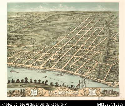
| dc.coverage.spatial | Clarksville, TN | - |
| dc.date.accessioned | 2013-04-03T15:45:35Z | - |
| dc.date.available | 2013-04-03T15:45:35Z | - |
| dc.date.issued | 1870 | - |
| dc.identifier.uri | http://hdl.handle.net/10267/16135 | - |
| dc.description.abstract | Street map of Clarksville TN in 1870. | en_US |
| dc.publisher | Memphis, Tenn. : Rhodes College Archives and Special Collections | en_US |
| dc.rights | Rhodes College owns the rights to the archival digital images in this repository. Images are made available for educational use only and may not be used for any non-educational or commercial purpose. Approved educational uses include private research and scholarship, teaching, and student projects. For additional information please contact archives@rhodes.edu. | - |
| dc.subject | Clarksville, Tennessee | en_US |
| dc.subject | Buildings and grounds | en_US |
| dc.subject | Maps | en_US |
| dc.title | Clarksville, TN Street Map | en_US |
| dc.type | Other | en_US |
| Appears in Collections: | Campus Buildings and Grounds | |
Files in This Item:
| File | Description | Size | Format | |
|---|---|---|---|---|
| 1870_ClarksvilleTN_street_map.jpg | 52.99 kB | JPEG |  View/Open |
Items in DSpace are protected by copyright, with all rights reserved, unless otherwise indicated.