Please use this identifier to cite or link to this item:
http://hdl.handle.net/10267/23056Full metadata record
| DC Field | Value | Language |
|---|---|---|
| dc.contributor.author | Student Affairs, Office of | - |
| dc.date.accessioned | 2014-07-18T17:09:07Z | - |
| dc.date.available | 2014-07-18T17:09:07Z | - |
| dc.date.issued | 2011 | - |
| dc.identifier.uri | http://hdl.handle.net/10267/23056 | - |
| dc.description.abstract | This features a map of the Rhodes campus during construction of West Village, a list of buildings with wheelchair accessible restrooms, a list of buildings that require a fob for entrance, and contact information for Campus Safety and the Office of Student Disability Services. | en_US |
| dc.publisher | Memphis, Tenn. : Rhodes College | en_US |
| dc.rights | Rhodes College owns the rights to the archival digital images in this repository. Images are made available for educational use only and may not be used for any non-educational or commercial purpose. Approved educational uses include private research and scholarship, teaching, and student projects. Original copies of the minutes are stored in the College | - |
| dc.subject | Campus maps | en_US |
| dc.subject | Construction | en_US |
| dc.subject | Wheelchairs | en_US |
| dc.subject | Entrances | en_US |
| dc.subject | Images | en_US |
| dc.subject.other | Student Affairs, Office of | - |
| dc.title | Campus Map and Accessibility Guide | en_US |
| dc.type | Image | en_US |
| dc.type | Other | en_US |
| Appears in Collections: | Students Affairs. Documents | |
Files in This Item:
| File | Description | Size | Format | |
|---|---|---|---|---|
| Campus_Map_Accessibility_2011_002.pdf | Campus map and accessibility 2011 | 1.39 MB | Adobe PDF | 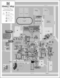 View/Open |
Items in DSpace are protected by copyright, with all rights reserved, unless otherwise indicated.