Please use this identifier to cite or link to this item:
http://hdl.handle.net/10267/34156
| Title: | Chili |
| Issue Date: | 1628 |
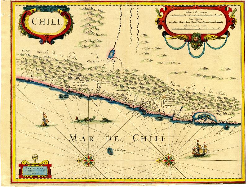
| Abstract: | Willem Blaeu's very decorative map of Chili with two large and beautiful cartouches, a compass and ships. The modern cities of Santiago (identified on the map as "S Iago della Nueva Estremadura", Valparaiso (as a river estuary of "ValParayso"), Concepcion, and Valdivia (as Baldiva) are all shown on the map. At the left-hand side) as far south as the Atacama desert in the northern reaches of Chile. Featuring large decorative cartouche, elaborate compass rose, 4 sailing ships and 3 sea monsters. Nearly 100 place names shown, with extensive details throughout the map. Although the interior terrain is not mapped with any particular degree of accuracy, Blaeu's map nevertheless conveys a vivid impression of the difficult terrain of the Andes in Peru. 'As early as 1520, Spanish settlers in Panama had heard tales of a powerful civilization rich in gold that lay to the south, and in 1522 an expedition was organized to find this land and the people called Birú or Pirú in the south. In 1524 Francisco Pizarro led the first of his expeditions that led ultimately to the discovery and conquest of the Inca empire which extended over wide areas of modern Ecuador, Peru, Bolivia and part of Chile. Pizarro obtained from Atahuallpa, the head of the Inca empire, a huge ransom of silver and gold that made Spain rich almost beyond the most inventive dreams of the Spanish conquerors, and once the mountain city of Cuzco was captured in 1533, the Spanish hold over much of South America was virtually complete." (Goss) |
| URI: | http://hdl.handle.net/10267/34156 |
| Appears in Collections: | Warner Map Images |
Files in This Item:
| File | Description | Size | Format | |
|---|---|---|---|---|
| Warner_Maps_05.jpg | 26.61 MB | JPEG |  View/Open |
Items in DSpace are protected by copyright, with all rights reserved, unless otherwise indicated.